Hazards - Know your risks

Flooding

There are different types of flooding that affect our region:

Riverine flooding happens when widespread and prolonged rain falls over the catchment area.

The impact of riverine flooding is dependent on the flood level classification:

  • Minor flooding causes inconvenience such as closure of minor local roads and low bridges.
  • Moderate flooding causes low lying areas to be inundated, requiring removal of stock, equipment and evacuation of homes. Some major roads or access points may be covered.
  • Major flooding causes extensive inundation of rural and/or urban areas with isolation of towns and property causing extensive damage.

Flash flooding usually results from relatively short, intense bursts of rainfall, commonly from thunderstorms. Flash floods are usually local, and it is difficult to provide effective warning because of their rapid onset. This type of flooding resolves quickly as water tends to disperse once the storm passes.

What are the local risks?

The Bundaberg Region is prone to riverine flooding with several river catchments running through the area. The Burnett River Basin is vast and funnels water to the ocean through the centre of Bundaberg.

It is important that everyone is prepared for future riverine floods and understands how floods might impact them. Bundaberg Regional Council offers free access to Burnett River flood information. Check your flood risk here.

Flash flooding is common in the Bundaberg Region with low lying roads commonly impacted for a short period of time.

Warnings

Bundaberg Regional Council in conjunction with the Bureau of Meteorology and neighbouring Councils operates a flood warning system for the main river catchments through river and rain gauges. This enables accurate and timely flood warnings and forecasts.

You can Opt-In on the Bundaberg Disaster Dashboard to receive alerts on river levels.

How to Prepare

What to do during

After an event

DO NOT ENTER FLOODWATERS – IF IT’S FLOODED, FORGET IT!

  • Pay attention to all warnings.
  • Do not go sightseeing.
  • Check and offer help to neighbours, friends and family.

Severe weather

Severe weather includes Severe thunderstorms, tornadoes and east coast lows. Severe weather can threaten lives, cause damage and destruction and bring hazardous weather conditions, such as:

  • Lightning
  • Large hail or giant hail
  • Tornadoes
  • Very heavy or intense rainfall that may lead to flash flooding
  • Damaging or destructive winds
  • Storm surge, dangerous surf and abnormally high tides

What are the local risks?

Severe storms can be unpredictable and occur with little warning. Severe thunderstorms generally occur within the Bundaberg Region between January to March but are also likely during the months of April, November and December.

Be aware of severe storm patterns in your area, for example, which direction the storms typically come from, where does storm water flow, where the rivers and creeks are, if your property at risk of storm tide inundation, and what are your potential evacuation routes.

Warnings

Severe weather warnings are issued by the Bureau of Meteorology (BOM) for:

  • Damaging winds including sustained gale force winds (63 km/h or more) and damaging wind gusts (90 km/h or more).
  • Heavy rain that may lead to flash flooding.
  • Abnormally high tides or Hazards - know your risks that may be higher than the highest astronomical tide.
  • Damaging surf, or ‘dangerous surf’, with unusually large surf that may cause dangerous conditions on the coast.

You can Opt-In on the Bundaberg Disaster Dashboard to receive severe weather warnings.

How to prepare

What to do during

  • Stay informed. Tune your battery-operated radio into ABC 100.1 FM
  • Listen for warnings and alerts and follow any instructions given.
  • Stay inside and shelter well clear of windows, doors and skylights.
  • If driving, stop clear of trees, powerlines and creeks.
  • Do not use a fixed telephone during a severe storm due to lightning danger.
  • Turn off and unplug electrical items, external TV/radio aerials and computer modems.
  • If outdoors, seek solid enclosed shelter.
  • If the building starts to break up, shelter under a mattress, doona, or a strong table or bench in the strongest part of the building, eg internal room, hallway or built-in wardrobe

After an event

  • Pay attention to all warnings.
  • Stay away from damaged power lines, fallen trees, flooded waterways.
  • Check for structural property damage.
  • Do not go sightseeing.
  • Check and offer help to neighbours, friends and family.

Cyclone

Tropical cyclones are low pressure systems that form over warm tropical waters, generally intensifying over several days, generating severe wind, heavy rain and flooding. They are powerful weather systems that can cause significant damage to the built and natural environment and can continue for many days, even weeks.

The severity of a tropical cyclone is described in terms of categories relating to the strength of the winds ranging from 1 (weakest) to 5 (strongest).

Category Typical strongest gust Typical effects
1
Tropical Cyclone
Less than
125 km/h Gales
Minimal house damage. Damage to some crops, trees, caravans. Boats may drag moorings.
2
Tropical Cyclone
125-164 km/h
Destructive Winds
Minor house damage. Significant damage to signs, trees and caravans. Heavy damage to some crops. Risk of power failure. Small boats may break moorings.
3
Severe Tropical Cyclone
165-224 km/h
Very Destructive Winds
Some roof and structural damage. Some caravans and boats destroyed. Power failures likely.
4
Severe Tropical Cyclone
225-279 km/h
Very Destructive Winds
Significant roofing and structural damage. Many caravans and boats destroyed and blown away. Dangerous airborne debris. Widespread power failures.
5
Severe Tropical Cyclone
More than 280 km/h
Extremely Destructive Winds
Extremely dangerous with widespread destruction.

What are the local risks?

Bundaberg has a risk of being impacted by cyclones during the cyclone season that officially runs from November to April. Tropical cyclones can be erratic, and a cyclone of any size can be dangerous. Even when a tropical cyclone weakens to a tropical low, it can bring dangerous conditions.

Warnings

The Bureau of Meteorology (BOM) issues warnings for Tropical Cyclones:

  • A Tropical Cyclone Advice - a “notice” that advises the location of a cyclone, its movement and intensity, and identifies areas that could be affected.
  • A Cyclone Watch is issued 48 hours before the cyclone is predicted to cross the coast. Updated every six hours, a Cyclone Watch provides information on the location, movement and intensity, and areas that could be affected.
  • Cyclone Warnings are issued if winds are expected to affect coastal or island areas within 24 hours. The warning is updated every three hours and then every hour if the cyclone poses a major threat. The warning includes information on location, movement and intensity of the cyclone, areas that are threatened and anticipated rainfall, flooding and storm surge.

BOM also provides a track map for each cyclone showing forecast movement, intensity, watch or warning zones. Cyclone track map can also be found on Bundaberg's Disaster Dashboard.

How to prepare

What to do During

  • Stay informed. Tune your battery-operated radio into ABC 100.1 FM
  • Listen for warnings and alerts and follow any instructions given.
  • Be aware of your shelter and evacuation options
  • Stay inside and shelter in the strongest part of the building keeping well clear of windows (eg shelter in the internal hallway or bathroom).
  • Turn off and unplug electrical items, external TV/radio aerials and computer modems.
  • If the building starts to break up, shelter under a mattress, doona, or a strong table or bench in the strongest part of the building, eg internal room, hallway or built-in wardrobe.
  • Beware the calm ‘eye’ of the cyclone. If the wind drops, do not assume the cyclone is over. Violent winds will soon resume from another direction. Wait for the official “all clear”.

After an event

DO NOT ENTER FLOODWATERS - IF ITS FLOODED, FORGET IT!

  • Pay attention to all warnings.
  • Do not go outside until officially advised it is safe.
  • Do not make unnecessary phone calls.
  • Stay away from damaged power lines, fallen trees, flooded waterways.
  • Check for structural property damage and gas leaks.
  • Do not use electrical appliances if wet.
  • Follow any instructions for treating drinking water and discard any contaminated food.
  • Do not go sightseeing.
  • Check and offer help to neighbours, friends and family.

Bushfire

Bushfires occur when areas of vegetation ignite and burn through reserves, national parks, private property and urban corridors. Bushfires can cause serious property and infrastructure damage and lead to loss of life. Other impacts from bushfires include:

  • Fire embers that can spread many kilometres from the location of a large fire, causing smaller spot fires to break out.
  • Radiant heat that can be felt more than 100m away from a large bushfire and has the potential to melt or fracture objects including parts of cars, glass windows etc.
  • Toxic fumes and heavy smoke that can impair vision and impact on air quality, creating difficulties in breathing.

What are the local risks?

Check the Queensland Fire Department (QFD) Post Code Checker to find out the bushfire potential in your neighbourhood.

Generally, the fire season is through winter (dry season) and spring months however can vary depending on the condition of local bushland, long-term climate and short-term weather conditions. You do not have to live in the bush to be threatened by bushfire, just close enough to be affected by burning material, embers and smoke.

Bushfires are most likely to occur when the weather is very hot and dry and can start from human activity or natural causes such as lightning strikes. Fires can move extremely fast – faster than you can run. They can also be unpredictable, changing direction.

Bushfire warnings

Everyone should be familiar with the official Bushfire Warning system. When there is a bushfire in your area, it is up to you to take notice, seek information, make decisions and act.

When warnings are given, act immediately on the instructions provided. Do not wait. Leave when advised, even if it feels safe where you are at the time. Take your household emergency kit with you. Go in the direction advised for your location.

The Australian Fire Danger Rating System is used to communicate the level of bushfire risk. The higher the rating the more dangerous the conditions are likely to be.
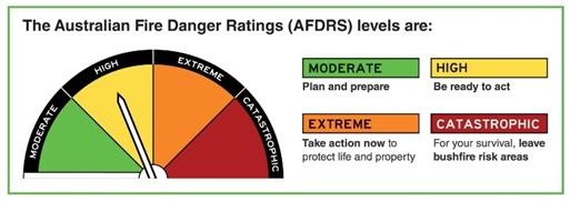
Australian Fire Danger Rating System

If lives or property are threatened, Queensland Fire Department (QFD) issues warnings at an Advice, Watch and Act or Emergency Level:

""Advice tells you a fire has started and provides general information to keep you updated.

There is no immediate danger, but you need to stay informed in case the situation changes.


""Watch and Act represents a heightened level of threat and conditions are changing.

Act now to protect yourself and your family.


""Emergency is the highest level advising you are in danger. You need to take life-saving action immediately.


Current fire warnings can be found on the Bundaberg Disaster Dashboard and on the Queensland Fire Department (QFD) website via the red "Bushfires and Warnings" button in the top right corner.

How to prepare

Preparation is the key to survival. A Bushfire Survival Plan will help you prepare and know what action to take if threatened by a bushfire. Based on the Fire Danger Ratings, your plan should be written down and practiced regularly and consider the ages and physical capability of everyone in your household.

QFD Bushfire Safety Guide also provides more information on bushfire risk and how to prepare for bushfire.

What to do during

Due to the unpredictable nature of fast-moving fires, people are likely to be encouraged to evacuate from their homes as quickly as possible to ensure they can reach safety. If you plan to leave early, then you must leave your home well before a bushfire threatens and traveling by road becomes hazardous.

After the event

  • Pay attention to all warnings.
  • If evacuated, wait until the all-clear has been given by emergency services before leaving your safe area.
  • Check the property for damage. If unsure about the safety of the property, seek advice from local Emergency Services. Do not take any risks.
  • Do not go sightseeing.
  • Check and offer help to neighbours, friends and family.

Coastal Inundation

With almost 100 kms of coastline, the Bundaberg region is vulnerable to coastal inundation. i.e. when sea water rises high enough that it floods infrastructure and buildings or endangers people’s safety. Coastal inundation can be caused by:

  • Storm surge – a rise above the normal water level along a shore resulting from strong onshore winds and/or reduced atmospheric pressure. Usually caused as a cyclone reaches the coast, the huge winds whip up the sea and push the dome of water over low-lying coastal areas. The waves and sea water can move inland quickly, damaging buildings and cutting off escape routes.

    Coastal Inundation Graphic

  • The combination of storm surge and normal (astronomical) tide is known as Storm tide. The worst impacts occur when the storm surge arrives on top of a high tide and when this happens, the storm tide can reach areas that might otherwise have been safe.
  • While storm surges and storm tide are generated by weather systems forcing water onshore, it is generally over a limited stretch of coastline. Tsunami - a series of powerful, fast-moving waves usually associated with earthquakes, landslides or volcanic eruptions, explosion or other ocean disturbance can affect vast lengths of coastal land.

What are the local risks?

The Bundaberg Region is at risk of being impacted by cyclones during ‘cyclone season’ which officially runs from November to April, with several low-lying coastal areas at risk from storm surge and storm tide. Storm Tide Evacuation Maps have been created for coastal communities within the Bundaberg region so you can check your risk.

There is little recorded history of tsunami in Australia. Tsunami is a low risk, high consequence hazard for the Bundaberg region and it is expected the Great Barrier Reef could reduce tsunami risk, however unpredictable local effects should not be discounted. Council provides Tsunami Inundation Mapping so you can prepare if you live in a coastal area that potentially could be affected by tsunami.

Storm tide evacuation mapping and Tsunami Inundation Mapping can be found on the Bundaberg Disaster Dashboard.

Warnings

Advice on possible storm sturges and storm tides are included in cyclone warnings issued by the Bureau of Meteorology (BOM).

The Joint Australian Tsunami Warning Centre detects and verifies any tsunami threat to the coastline of Australia and provides warnings. Warnings will then be relayed via official channels.

If a warning is issued - follow instructions immediately!

How to prepare

After an event

DO NOT ENTER FLOODWATERS - IF IT'S FLOODED FORGET IT!

  • Pay attention to all warnings.
  • Do not go outside until officially advised it is safe.
  • If you have evacuated, do not return home until officially advised it is safe.
  • Beware damaged power lines, bridges and trees.
  • Do not enter flood waters.
  • Do not go sightseeing.
  • Check and offer help to neighbours, friends and family.

Heatwave

A heatwave occurs when the maximum and the minimum temperatures are unusually hot over a three-day period. Heatwaves can impact anyone but babies, young people, elderly people, pets, those working outdoors and those with medical conditions are particularly vulnerable. Heatwaves can also cause disruption to the power supply, public transport and services.

What are the local risks?

Heatwaves in Queensland typically occur between October and March but are most common in January.

Warnings

The Bureau of Meteorology (BoM) issues heatwave forecasts and warnings from October until the end of March, depending on conditions. The BOM classifies heatwaves into three types, based on intensity:

  • Low-intensity heatwaves are more frequent during summer. Most people can cope during these heatwaves.
  • Severe heatwaves are less frequent and are likely to be more challenging for vulnerable people such as the elderly and those with medical conditions.
  • Extreme heatwaves are rare. They are a problem for people who do not take precautions to keep cool – even for people who are healthy. People who work or exercise outdoors are also at greater risk of being affected.

How to prepare

  • If you have a medical condition, ask your doctor for advice on how to manage the heat.
  • Think about modifying your planned activities so that you are indoors or in air-conditioning.
  • Install blinds, curtains or other devices which help to keep the heat out.
  • Check your fans and air-conditions are working property.

What to do during

  • Drink plenty of water regularly.
  • Keep out of the heat as much as possible, especially between 11 am and 3 pm.
  • Close curtains and blinds to keep rooms cool.
  • Avoid strenuous activities.
  • Wear loose, cool clothing and wear a hat, glasses and sunscreen if going outside.
  • Have cool showers or baths or splash yourself with cold water.
  • Look after your animals.

After an event

  • Check on friends and vulnerable people who may be less able to look after themselves.

Earthquake and Landslide

Earthquake

  • Earthquakes are the vibrations caused by rocks breaking under stress. Earthquakes in Australia are usually caused by movements along faults as a result of compression in the Earth’s crust.
  • Earthquakes are unpredictable and strike without warning. They can occur at anytime of the day and any time of the year. They range in strength from slight tremors to great shocks lasting from a few seconds to a few minutes.

Earthquakes can cause:

  • Damage to the electricity and telecommunication networks caused by fallen powerlines.
  • Broken or split sewer and water mains
  • Damage to roads and bridges that may make them unsafe to drive on.
  • Landslides.
  • Destruction or damage to buildings making them unstable and unsafe.

What are the local risks?

Most of Australia is rated as having a “low risk” status, however earthquakes occur within the Bundaberg Region more often than you would think. Earthquakes experienced in recent history have been located within rural areas and not caused damage to property or put lives at risk however it is important to be aware of the dangers associated with earthquakes and what to do if one should occur.

Secondary impacts associated with earthquakes include tsunamis and landslides.

Warnings

There may be little if any warning of an impending earthquake – it is possible you will feel it before emergency services know it is going to happen.

How to prepare

What to do during

  • Stay informed. Tune your battery-operated radio into ABC 100.1 FM
  • Listen for warnings and alerts and follow any instructions given.
  • If indoors – stay there (clear of falling debris outside).
  • Keep clear of windows, chimneys and overhead fittings. Shelter under and hold onto a door frame, strong table or bench.
  • In high-rise buildings, stay clear of windows and outer walls. Shelter under a desk or near a pillar or internal wall.
  • Do not use elevators.
  • If outside, keep well clear of buildings, overhead structures, walls, bridges, powerlines and trees.
  • In a vehicle – stop in an open area until the shaking stops.

After the event

  • Expect aftershocks.
  • Pay attention to all warnings.
  • Do not go sightseeing.
  • Check and offer help to neighbours, friends and family.
  • Turn off electricity, gas and water. Do not light matches until after you have checked for gas or fuel leaks.

Landslide

A landslide can be sudden and fast moving, shifting tonnes of earth, mud and rock. They can be caused by a major event such as an earthquake, however in Queensland, landslides are generally caused by heavy rain. The impact of a landslide can be extensive, including destruction of infrastructure, damage to land, loss of natural resources and, in extreme circumstances, loss of life.

What are the local risks?

Landslides can be triggered by natural causes or by human activity. They are not a common occurrence or a major threat in the Bundaberg region. Be aware of the area you live in – is it close to a hillslope, cliff or steep rocky area? Is there a history of landslides? If you live in such an area and there has been a period of heavy rain, you may be at risk.

Warnings

Emergency Services may have little or no warning of a landslide.

How to prepare

  • Monitor environmental conditions such as rainfall, erosion and earthquakes that could increase the risk of landslides.
  • Monitor movement of structures such as decks and patios, sticking doors or windows, tilting or cracking concrete floors and foundations, leaning poles, trees, retaining walls or fences.
  • Prepare your emergency plan, emergency kit, evacuation kit
  • Prepare your home
  • Prepare your business
  • Prepare your pets
  • Get to know your neighbours

What to do during

  • Follow any instructions from emergency services.
  • If indoors – shelter at the least-affected end of the building under a strong table or bench (if possible, use a mattress for extra protection). Hold on firmly and stay put until all land movement has stopped.
  • If outdoors and a landslide threatens, move quickly from its path and keep clear of banks, trees, powerlines and poles.
  • If it safe to do so, leave the area and go quickly to your agreed safer location.
  • Advise neighbours and emergency services of the slip threat.

After the event

  • Pay attention to all warnings.
  • Stay away from the slip area – there may be danger of additional slips.
  • Watch for flooding, which may occur after a landslide or debris flow.
  • If safe to do so, check for injured and trapped people near the slip and alert emergency services.
  • Look for and report broken utility lines, damaged roads to the appropriate organisation.
  • Check and offer help to neighbours, friends and family.